Our look at the current coverage of Kenya on the Kenya Bird Map continues with the coast. This area is special because it hosts many bird species that are not found anywhere else in Kenya. These are endemic and near-endemic species of the Zanzibar-Inhambane Coastal Forest Mosaic that extends across nearly the entire coast of Eastern Africa. They include Spotted Ground Thrush (Zoothera guttata), Sokoke Pipit (Anthus sokokensis), Sokoke Scops Owl (Otus ireneae), Amani Sunbird (Hedydipna pallidigaster), Pale (or East Coast) Batis (Batis soror), Southern Banded Snake Eagle (Circaetus fasciolatus), Green Barbet (Stactolaema olivacea), Clark’s Weaver (Ploceus golandi), Fischer’s Turaco (Tauraco fischeri), East Coast Akalat (Sheppardia gunningi) and Tiny Greenbul (Phyllastrephus debilis). This area is recognized as a biodiversity hotspot (the Coastal Forests of Eastern Africa Biodiversity Hotspot), due to the high number of endemic or range-restricted species that occur here.
Specifically, the Kenyan coastal region comprises of Kwale, Mombasa, Kilifi and Lamu counties along with the coastal section of Tana River County (inland to Lazima). Key features of this region include the Shimba Hills, Arabuko-Sokoke Forest, Dakatcha Woodland, Mida Creek, Tana River Delta, Sabaki River Mouth and the Indian Ocean islands (Lamu Archipelago, Whale Island, Kisite and Mpunguti Islands etc).

Coverage
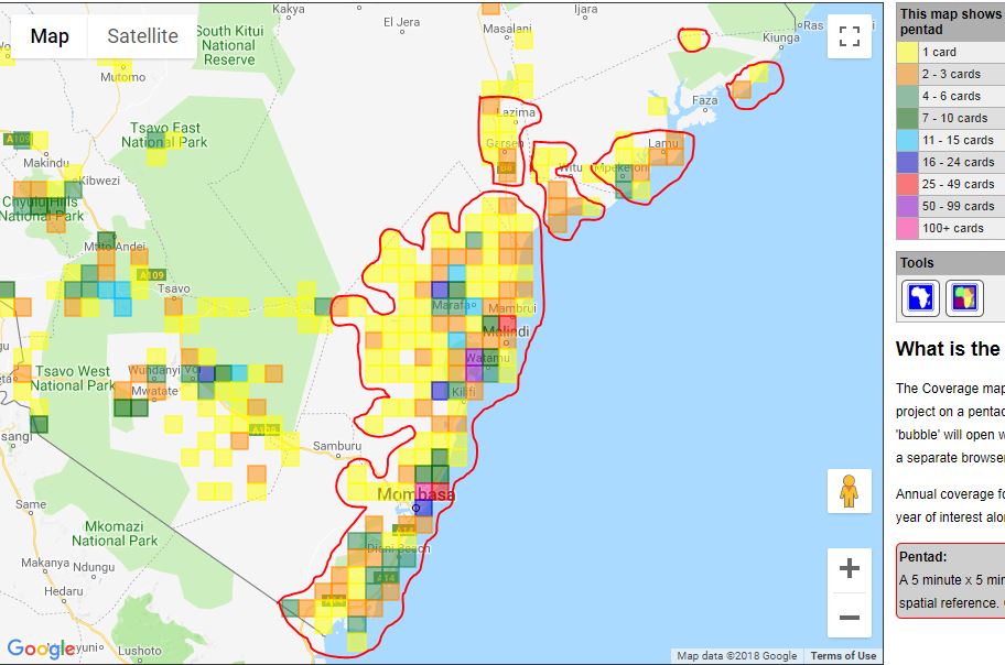
The coast is the second-best covered region on the Kenya Bird Map, behind the central highlands. Unlike central Kenya however, there are relatively few active bird atlassers at the coast. Most of the records from this region have in fact come from a handful of very enthusiastic resident atlassers. Visiting birders have also contributed records, especially for some of the more popular birding destinations such as Arabuko-Sokoke Forest and Mida Creek.

The central and southern parts of the coast are the region’s best-covered areas. A solid block of atlassed pentads stretches from the Kilifi-Tana River counties boundary south to Vanga near the Tanzania border, with only one pentad (between Shimoni and Vanga) along the entire coastline being untouched! This is an amazing achievement by the coastal atlassers!
In the south coast (Kwale County), the coverage stretches inland to the Shimba Hills and Mwaluganje Elephant Sanctuary. In Mombasa, the Mtwapa Creek pentad is colored pink (100+ full protocol cards) and is by far the most intensely-atlassed pentad on the coast! By contrast, the Mombasa International Airport pentad bordering this intensely covered pentad to the south-west has zero cards and is the only untouched pentad in Mombasa County. The coverage of Kilifi County forms the broadest band of covered pentads on the coast – stretching from the Indian Ocean to the county boundary near Tsavo East National Park. The lower Tana River, including the Tana Delta, has some coverage from Lazima through Garsen to Kibusu and also a few pentads near Kipini. Lamu County is the least-covered county, with only a few pentads around Mpeketoni and Lamu, one at Magumba, two near Kiunga Marine Park and one north of Dodori National Reserve covered. Understandably, this is mainly due to insecurity in the area.
The Gaps
In Kwale County, the entire area west and north of the Shimba Hills is poorly covered. The few pentads that have been atlassed in this area (including the Mwalunganje Elephant Sanctuary pentad) have less than 4 full protocol cards (yellow or orange). Majority of the pentads are completely untouched.
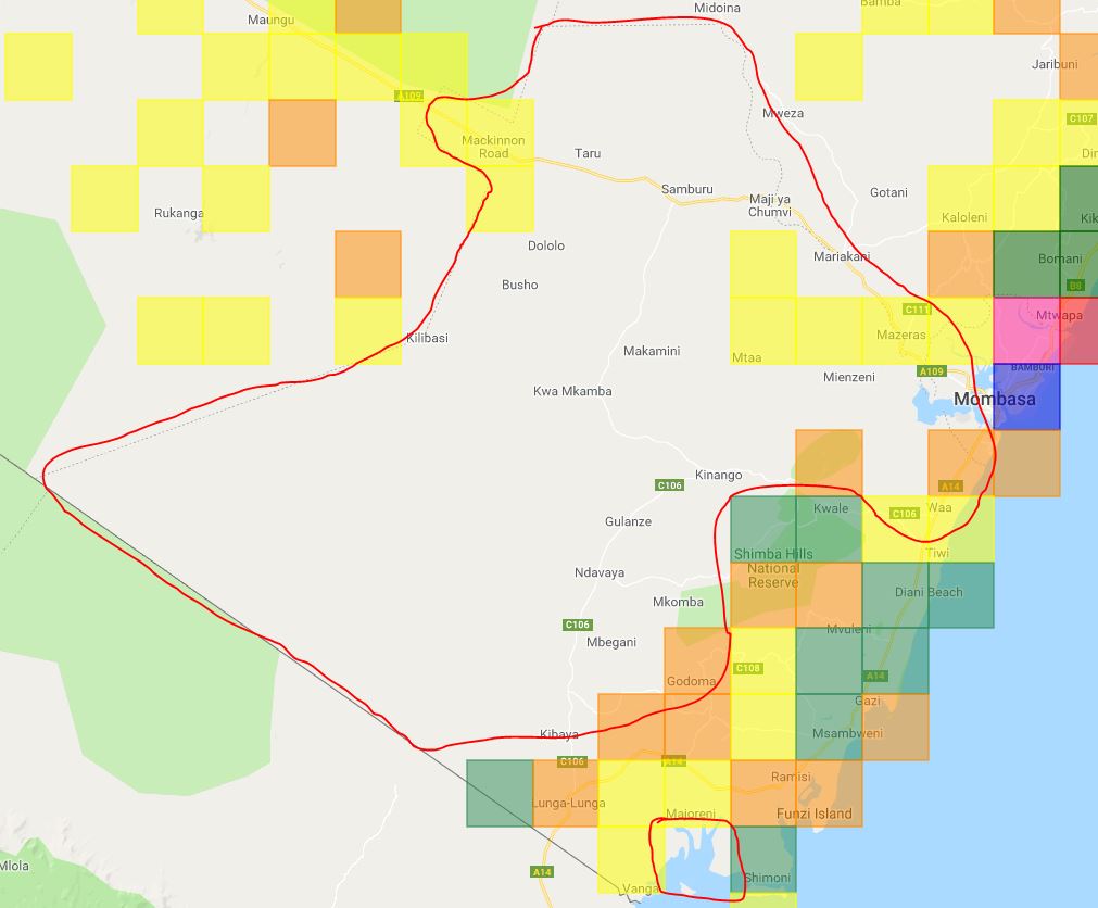
As mentioned earlier, the only untouched pentad in Mombasa County lies to the south-west of the heavily-atlassed Mtwapa Pentad (pink on the map above). It is a very urban pentad that contains Mombasa International Airport, Port Reitz and the city’s industrial area – understandably not a very appealing area to go birding, but still worth documenting what is there.
The main gaps in Kilifi County are north-west of Kamale, west of Dakacha and south-western areas of the county including Gotani, Mweza, Goshi and Gede. Although this county has the broadest coverage of all the coastal counties, most of the pentads are yellow (i.e. only one full protocol card) or orange (2-3 fp cards) and so need to be visited several more times in order to get a fuller picture of the birds that occur in them.

Tana River and Lamu counties have the poorest coverage. In fact, pretty much all the pentads in the entire area are either untouched or have less than 3 full protocol cards. Only two pentads, the Mpeketoni pentad and the one bordering it to the south, have at least four full protocol cards (the minimum recommended in order to get a fairly accurate picture of the birds that occur in the area). Insecurity is the main factor that keeps bird atlassers away from this area.

The most important thing to note about coverage at the coast is that, although a broad area has been covered, a vast majority of the atlassed pentads have less than four full protocol cards (yellow and orange in color) and so are not adequately covered. It is important that more effort is put into improving coverage in this biologically rich and unique part of Kenya. Apart from improving our understanding of the current distribution and status of coastal species, bird mapping will also help monitor populations of the exotic and destructively invasive House Crow as effort are made to reduce its numbers and control its spread inland (read more on how this works in this article).
If you are a birder who lives at the coast or are planning to visit the coast soon and are not yet registered on the Kenya Bird Map, please send an email to kenyabirdmap@naturekenya.org to get registered as a citizen scientist and contribute you bird records to the project. For those who have been submitting their records, well done and please keep more records coming in!
Feel free to visit the Kenya Bird Map website to learn more about the project and see all the coverage gaps on the coverage map. Check back on the KBM blog next Friday to see how the western region of Kenya is faring on the Kenya Bird Map!

2 thoughts on “The Current Status of Kenya’s Bird Atlas: Part 3 of 7 – The Coast”